Nakayama is in between Narita And Haneda International Airport
<クッキーについての同意並び欧州居住者向けプライバシーポリシー>
中山・下総・散歩道
Suruga-no-kuni : The Short Summary Of Suruga Province
Suruga-no-kuni was an administrative district in classic Japan. The area of Suruga Province was located on the central part of Shizuoka Prefecture. There was Kai Province (Yamanashi Prefecture) in the north, Izu Province in the east, Totomi Province in the west, and there was the Pacific Ocean lying in the south. Suruga-no-kuni belonged to Tokai-do region, and it was counted as a upper grade and middle distant country. The provincial government and the Kokubunji Temple of Suruga might be in at Shizuoka city in Shizuoka prefecture. And Fujisan Hongu Sengentaisya Shrine also in Fujinomiya city was registered as Ichinomiya (the first shrine) of Suruga Province. First Izu-no-kuni east side of it belonged to Suruga at Taika Reform in 645. In 680, Izu was registered as a province, and the area belonged to Suruga was confirmed.Late Heian Period, there were many private estates owned by nobles in Kyoto, large temples and shrines in Suruga Province, then many officers came from Kyoto and managed the estates, finally most of them settled in and became powerful local clans. Nobuyoshi Takeda at Kai Province was appointed as the military governor of Suruga Province before the Battle Of Fujigawa River in 1180. However, the position was taken over the head family of Hojo Clan in Kamakura through Kamakura Period. Suruga was very important region on the way from Kamakura to Kyoto. By the way, tea plantation started at Abegawa area by Enni a priest of Kenjinji Temple at Kamakura of Rinzai Sect of Buddhism in Kamakura Period.
In 1338, Norikkuni Imagawa was appointed the military governor of Suruga Province by his achievement in the Battles at Genko and Kenmu in the Period of the Northern and the Southern Dynasties, and the Imagawa Clan succeeded the position through most of Muromachi Period. Suruga Province was the forefront to press samurai in Kamakura and east Japan. While the conflicts between Muromachi Bakufu and the government in Kamakura became aggressive, the Imagawa Clan fought at several battles to surpress rebels in east, the Revolt of Zenshu Uesugi in 1416 and Eikyo War 1439 were the famous achievement of the clan. During under controlling of Yoshomoto Imagawa, Surga Proince was flourished, many nobles and artists came to visit the province, and it was called 'the capital in east' and 'Kyoto in east'. However, Yoshimoto was killed at the Battle Of Okehazama by Nobunaga Oda, the most popular sengoku busho in Japan at Owari Province in 1560. After lost the battle, the power of the Imagawa Clan decreased. In 1569, Shingen Takeda at Kai invaded to Suruga and he conquered it. Moreover, in 1582, Ieyasu Tokugawa gained the power to control Suruga after Nobunaga and he ruined the Takeda Clan. In 1590, Ieyasu moved to Edo (Tokyo), then Kazuuji Nakamura and his son Kazutada a vassal of Hideyoshi Toyotomi moved to Suruga. In 1600, Ieyasu won the Battle of Sekigahara and gained the power to control Japan. He took back Suruga Province under his control.
Ieyasu Tokugawa lived in Suruga Province to administrate Japan as the retired and still de facto Shogun until he died in 1616. Suruga Province was strategically very important region to protect Edo. In addition, there were 12 post towns on Tokaido road in the province, therefore many tourists and merchants past these towns and spent much money there so Suruga Province was flourished through Edo Period, Shimada, a specially famous town to cross Ooigawa River was crowded with thousands people to wait for the fine days to cross it. Edo Bakufu gained very large area to control directly with those strategic and economical reasons. And Kojima Clan was set in east Suruga and Tanaka Clan was set in west to protect.
After Meiji Restoration, the classical districts were rebuilt, Suruga merged with Izu and Totomi to be Shizuoka prefecture in 1871.
Suruga Province is now famous for Ieyasu Tokugawa, Mt. Fuj and tea leaves.
参考
静岡県ホームページ
デジタル大辞林
ブリタニカ国際大百科事典
日本大百科全書(ニッポニカ)
ウィッキウィッキペディア
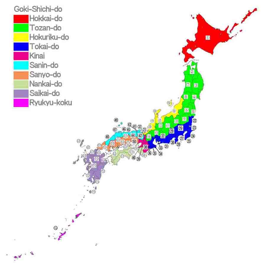
Blue represents Tokai-do and No.30 in the map below is Suruga-no-kuni
- 広告 Advertisement -