Nakayama is in between Narita And Haneda International Airport
<クッキーについての同意並び欧州居住者向けプライバシーポリシー>
中山・下総・散歩道
The Provincial Map Of Classic Japan
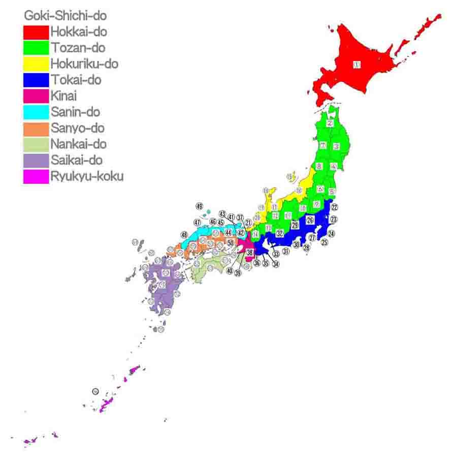
The picture below shows you the locations of the provinces in the classic Japan, it is very important to view this site, and of course it is very useful when you study and visit Japan. Sometimes , Japanese uses the names now, for example, Shimousa-Nakayama is a station name of JR East, so Shimousa is one of these provincial names. Shimousa was on the northern part of Chiba prefecture. Please use it and enjoy studing and visiting Japan.Before Meiji period, Japan was divided into the 66 provinces. And Tohoku region was diveided into only two provinces, one was named Mutsu, and another one is Dewa, but Mutsu was divided into 3, and Dewa is 2 at Maiji Restoration in 1868. In addition, on this map, Hokkai-do and Okinawa are also drawn.
Please check the locations of each provinces by the maps below, the each numbers on the map is equal to the numbers before each provinces' names. Please check them up.
On this map, Japan is diveided into 10 colors.
Red is Hokkai-do. Green is Tozan-do. Yellow is Hokuriku-do. Blue is Tokai-do. Pink is Kinai (the capital region). Light Blue is Sanin-do. Orange is Sanyo-do. Moss Green is Nankai-do. Purple is Saikai-do. Violet is Ryukyu.
Hokkai-do
1. EzoTozan-do
2. Mutsu 3. Rikutyu 4. Rikuzen 5. Iwaki 6. Iwashiro 7. Ugo 8. Uzen 9. Shimotsuke 10. Kamitsuke 11.Shinano 12. Hida 13. Mino 14. OmiHokuriku-do
15. Sado 16. Echigo 17. Ecchu 18. Noto 19. Kaga 20. Echizen 21. WakasaTokai-do
22. Hitachi 23. Shomousa 24. Kazusa 25. Awa 26. Musashi 27. Sagami 28. Izu 29. Kai 30. Suruga 31. Totoumi 32. Mikawa 33. Owari 34. Shima 35. Ise 36. IgaKinai
37. Yamashiro 38. Yamato 39. Kawachi 40. Izumi 41. SettsuSanin-do
42. Tanba 43. Tango 44. Tajima 45. Inaba 46.Houki 47. Izumo 48. Iwami 49. OkiSanyo-do
50. Harima 51. Mimasaka 52. Bizen 53. Bicchu 54. Bingo 55. Aki 56. Subo 57. NagatoNankai-do
58. Kii 59. Awaji 60. Sanuki 61. Awa 62. Iyo 63. TosaSaikai-do
64. Tsushima 65. Iki 66. Buzen 67. Chikuzen 68. Bungo 69. Hizen 70. Chikugo 71. Higo 72. Hyuga 73. Satsuma 74. Osumi 75. TanegashimaRyukyu
76. Ryukyu
The provinces' names are arranged in alphabetical order below. Maybe you can find easily.
A : 55. Aki 25. Awa 61. Awa 59. Awaji
B : 53. Bicchu 54. Bingo 52. Bizen 68. Bungo 66. Buzen
C : 70. Chikugo 67. Chikuzen
E : 17. Ecchu 16. Echigo 20. Echizen 1. Ezo
H : 50. Harima 12. Hida 71. Higo 22. Hitachi 69. Hizen 46. Houki 72. Hyuga
I : 36. Iga 45. Inaba 35. Ise 5. Iwaki 48. Iwami 6. Iwashiro 62. Iyo 28. Izu 40. Izumi 47. Izumo
K : 19. Kaga 29. Kai 10. Kamitsuke 39. Kawachi 24. Kazusa 58. Kii
M : 32. Mikawa 51. Mimasaka13. Mino 26. Musashi 2. Mutsu
N : 57. Nagato 18. Noto
O : 49. Oki 14. Omi 74. Osumi 33. Owari
R : 3. Rikutyu 4. Rikuzen 76. Ryukyu
S : 15. Sado 27. Sagami 60. Sanuki 73. Satsuma 41. Settsu 34. Shima 9. Shimotsuke 23. Shomousa 11.Shinano 56. Subo 30. Suruga
T : 44. Tajima 75. Tanegashima 42. Tanba 43. Tango 63. Tosa 31. Totoumi 64. Tsushima
U : 7. Ugo 8. Uzen
W: 21. Wakasa
Y : 37. Yamashiro 38. Yamato
- 広告 Advertisement -